The Hillary Trail was developed between 2005 and 2009, inspired from Sir Edmund Hillary who came to the Waitakere Ranges to prepare for his expedition to climb Mount Everest. It is built to be a challenging wilderness adventure taking trampers 70 km along the wild coastline of Waitakere Ranges. The original design and layout is set for a four day/three night hike, starting at Arataki Visitor Centre and Ending at Muriwai Beach. Alex and I decided to change the trek into a five day/four night trek, ending diverting to Swanson for public transport purposes rather than Muriwai Beach (we rerouted from junction with Kuataika, Houghton, Wainamu Bush and Smyth Ridge Track).
And so the morning of September 26, we set off to complete this trail, grabbing a ride with Ray (a friend at the hostel) in order to make it to the Arataki Visitor Centre. Once there we booked our nights at the campgrounds and bought a map of the trail. The ladies at the desk informed us that this trail is said to be really difficult. We were okay with that. They informed us that it would be incredibly muddy due to the time of year. We were okay with that too. They also made comments that they were surprised we were carrying so much weight. We simply told them that this was only the beginning for us. This was the test run for all our gear needed to go along the Te Araroa Trail and we needed it to be as realistic as possible.
They finally let us go so we could get on tramping.
------------------------------
DAY 1 (11 km) – September 26/10
Well – it’s been our first official trial trek day and it started off with a bang. First off – it turned out today began daylight savings here, but neither Alex nor I knew that. So we woke up later than what we wanted.
Regardless, we still managed to start out by 11am – thanks to a ride from Ray. We got dropped off at the Arataki Visitor’s Centre in Waitakere Ranges and headed off on the Hillary Trail after the visitor centre ladies questioned our choice of clothes and weight of packs (approximately 22kg each). We didn’t care that they told us the trail would be tough or that it was named after the first man to climb Everest. We were ready for anything.
 |
| Alex and I cozied up at the campsite |
And so we went – chatting away along the trail until we got to the first bit of mud that would last us nearly today’s entire journey. Sinking up to the tops of our boots, we squished and squashed our way along – all the while contemplating a local employee’s advice from Bivouac that we should be investing in some gators. While trudging our way along the first bit of the Hillary Trail we also came to the realization of why New Zealanders call it “tramping” as opposed to “trekking.” There wasn’t anything delicate about the way we made our way up and over mountains and along ridges. We tramped in every sense of the word – working as hard as we could and yet still being continuously overcome by local trail runners with calves the size of my quads.
We weeded our way in and around, climbing up and over a variety of nature life – a few times getting stuck in the mud – occasionally being able to catch glimpses of the magnificent valleys and mountains surrounding us. Five hours from when we started, Alex and I managed to find our way to the first campground. Set aside a small river and amongst rolling hills, we set up tent, at dinner and cleaned some clothes. Though our day proved to be rather uneventful (aside from the copious amounts of mud), it was perfect. We now have a much better idea of what gear works (my new trekking boots are awesome!) and what doesn’t (my water bottle broke already) – tomorrow will hopefully prove to be just as good!
DAY 2 (10 km) – September 27/10
Day #2 started out with us waking long before the 6am alarm and then lazily getting ready – reorganizing packs and such – before we set off on the trail at 8am.
 |
| View from uptop our last mountain climb |
Heading from our campsite at Karmatura, we made our way practically directly up a mountain. By this I do not mean the classic gentle slope that winds its way back and forth towards the peak of the giant form of rock. I mean – we literally climbed the mountain relatively straight up. Alex and I huffed and puffed as we put our muscles to good use. Each step was an effort and we were only grateful that there wasn’t any rain to be fighting off today as well.
The entire day was like being in one big sweat lodge as we would climb sharply up a mountain only to peak it and have to go just as steeply down. There were parts we had to literally scramble up the side of a rock face, forcing ourselves not to look down at the massive drop below as we heaved our bodies and packs just a little bit higher. And as hard as it was, it was well worth it. The views were spectacular and Alex and I made it to our destination – a local place called Whatipu Lodge – where we have been able to camp out on the front field. Gorgeous. Top off our day with freeze dried meals thanks to Back Country Cuisine (I had roast lamb with veggies) and life couldn’t be better!
DAY 3 (20 km) – September 28/10
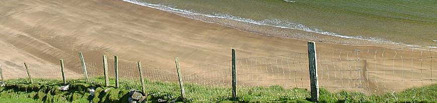
Today started off with us cutting half an hour off our packing time and then us continuing on our journey from Whatipu Lodge where we were tenting. Alex and I chose to take the beach route from there as the workers at Arataki Visitor’s Centre warned us the regular Hillary Trail route was currently flooded. And so we trekked for a good two hours along the black glistening sand, taking in the roar of the waves and relishing in the fresh sea breeze that whispered against our faces.
 |
| The beach |
By 9:30am we spotted a river exiting onto the shore of the beach. This was supposed to be our turnoff point to re-access the trail inland. Or so we hoped. There was no clear distinction of where we should head onwards to, aside from a piece of wood jutting from the sandy dunes that Alex had spotted. We shrugged off our packs, ate some trail mix and set out to explore the hopeful trail marker north of the river mouth. Five minutes down the trail, it still wasn’t entirely clear (no topographical map to do the comparison with) so we took a chance and decided to stick with it.
As it turned out, we were right and managed to reconnect with the Hillary Trail inland. And up the mountains we went, up along Zion Ridge Track and back down to the small town of Karekare. It was at this point, 6.5hrs into our journey that we realized we still had to get to the next town of Piha – a good 3hrs away – before we could set up camp.
Tired, thirsty, sore and hungry we trudged on, forever seeming to head up and up Waitakere’s many mountains. Eventually we made it to Piha and nearly squealed with joy to have found our destination. We secured a tent spot and went to the local store shortly before it closed to buy them out of their junk food. We were in heaven.
And so it’s been decided – we need one more day to enjoy Piha. One more day to rest ourselves. One more day to do nothing and prepare for the next part of our jouney.
DAY 4 (Rest Day) – September 29/10
 |
| Piha Beach |
Alex and I have decided to make today a rest day – much deserved after our lengthy 10 hour (7:30am-5:30pm) journey through Waitakere Ranges yesterday. After a glorious night of sleep, Alex and I have done as little as possible today.
We managed to sleep in until about 8am, when we lazed around in our tent deciding what to do. Eventually we made our way to have breaky in the camp kitchen and then later moseyed on down to the local beach to do some photography. The afternoon was spent chilling on some couches as we rested our aching bodies and caught up on our reading and journal writing. And then we ended off today by going local to try out a fish and chips special. After a day of recuperating, resting and eating more than our fill of food – we’re set for whatever the trail brings our way tomorrow.
DAY 5 (17 km) – September 30/10
Today we attempted to wake up SUPER early in order to get a head start on what we anticipated to be our hardest day yet. We were awake at 5am, but the sun had decided not to appear from behind the mountains until much later. So we waited. And waited. And waited. Eventually we set out by 7am (which was still our earliest time yet) and started heading north out of Piha.
Heading off today it seemed as though our day of rest in Piha had paid off. Sure, our muscles were still slightly tired and our bags were still heavy, but we had a certain bounce in our step that hadn’t been before. Perhaps we’ve come to a point where we’re starting to get stronger. Perhaps, in some ways we’ve begun to get used to the rhythm of tramping. Or – perhaps our packs are slightly lighter than the last time we put them on due to all the food we’ve been eating.
Regardless, the trail today did appear to be slightly easier than the last few days. Instead of a trail that petered on the edge of self destruction, full of knee-deep mud and rocks threatening to send us tumbling to the depths below we simply had to walk on a trail.
We eventually winded our way up a hill until we reached the top of the mountain and the view opened up to a local famer’s field – complete with cows. It was here that we got to experience some of New Zealand’s blustering winds to the point that when we went to put on our jumpers to shield us from the cold, Alex noticed that her rain cover for her pack had blown off. She debated whether to go back and look for it (keep in mind that we are at this point standing in the middle of a farmer’s field that is on top of a mountain – the pack cover could be absolutely anywhere) and I reminded her that though we’ve been lucky for weather so far, the next days are expecting to rain.
 |
| All geared up for the rain |
And so we left our packs there in the middle of the cow-trodden field and made our way backwards to double check that the pack cover didn’t just get caught up in a bush. We had just reached the entrance gate to the field when Alex yelled out that she had found it – and she had. We had been lucky that it had just blown off to the side of the track and was sitting there in the bushes.
From then on, our trek remained to be fairly uneventful and we happily tramped along, chatting away, taking time to be with our own thoughts, pointing out things to each other and making up songs about random things that came to mind. Eventually we made our way down the last bit of trail to our campsite and we started contemplating who would get to use the long drop (outhouse) first at the campsite. We were so stoked to get there that we didn’t want to have a break, but when we rounded a corner and came face to face with a massive muddy hill, we reluctantly decided to stop to regroup.
It was then that we pulled out the map and realized that we had gone a bit too far and had somehow missed the turnoff for out campsite. Alex and I debated what we should do as neither one of us are fans of backtracking and there was always the option of simply camping on the side of the trail if we wanted to. But the knowledge that we had somehow passed a sign that could be so blatantly obvious for our campsite didn’t sit well for us. So we turned around and retraced our steps. But we couldn’t find it.
We cross-referenced the map numerous times, analyzing the corners, the streams, the bumps and ridges of what would have been there had the map been topographical. But it wasn’t topographical and we were tired of going around in circles trying to find something that apparently wasn’t there. And so we found a little grass patch next to the path near a stream crossing and pitched our tent.
And now the rain has begun to fall.
DAY 6 (10 km) – October 1/10
Alex and I woke to the rain that had been pounding down on our tent all night long. We knew that today was the day we were due to be back at the hostel, but I don’t think either one of us wished to get out of bed. That being said I really had to go to the bathroom – really bad. I had avoided getting out of the tent all night as that would mean trying to figure out how to get out of the sleeping bag, find my rain gear (all still in my pack), get it on, get out of the tent without letting water in and find a spot to go to the bathroom in the dark. Not my idea of a good time. So I held on till morning when I REALLY had to go.
As Alex and I were figuring out our strategy to pack up everything without getting wet, I thought that I should get on the whole bathroom situation. So I found my rain jacket and got it on, but when I went to unzip my tent, my headlamp shone outside where about a million mosquitoes were making the layer in between our tent and the tent fly their new home. And they were ready and eager for some morning breakfast – my skin.
And so we moved onto Plan B. Not getting out of the tent until as late as possible. We packed up our sleeping bags and mats as well as all our clothes. We made our oatmeal in the tent – against all warnings of the camp stove company (sorry guys) and even brushed our teeth within the cozy surroundings of our two-man tent. Eventually the time came where there was nothing we could possibly do to delay getting outside any longer and so we got on with it.
I got all geared up in my rain clothes – a heavy duty rain jacket from Swazi and my rain pants. I put my feet in my hiking boots to find them still soaked from yesterday’s two river crossings that I didn’t do so gracefully at, but synched up the laces anyway. Today I was going to be wet regardless of how I started out.
And then I went out to face the swarm of mosquitoes.
By the time we packed up all our gear and put on our packs, the rain had lessoned, but one look at the skies told us it would be back. And so we walked. And then it rained. And then we walked some more. Three times we crossed flooded rivers (a big no-no in the trekking book, I know) simply because today was our last day and we assessed the rivers to still be doable for us to give it a go. Fortunately today (unlike yesterday) we took the time to change into our water shoes made more for the slippery river rocks, thereby avoiding the unnecessary flooding of our hiking boots.
By 1pm we had made our way to Swanson where we were able to catch the train into Auckland. We smelled. We were muddy beyond belief. We were done.
And now, we’ve made it back to the hostel we started at and it feels weird. I feel as though I have changed in the last few days and yet everything is still the same. It feels as though our time in the Waitakere Ranges was all just a dream and yet at the same time I know it wasn’t.
------------------------------
Now that we have been at the hostel for a few day, I have had some time to reflect on our journey along the Hillary Trail. Sure, it wasn’t even a fraction of the distance we will have to do during Te Araroa Trail, but I still think we got out everything from it that we wanted. We experienced the mud. The beach shores. The rocky ridges. The glorious mountain peaks. Farmer fields. Road walking. River crossings. Rain. And everything in between.
 |
| Alex scraping her boots |
We also did our bit to help prevent the spread of Kauri Dieback disease in the forests. It’s currently spreading through spores and such on the ground, killing New Zealand’s treasured Kauri trees. Throughout our journey Alex and I had to continuously stop to brush off our boots and then spray them with disinfectant to prevent the disease from going further. As we trekked along the Hillary Trail, we were able to see parts that were more affected than others – the beautiful trees withering before our eyes. And so we did our part as best we could – not minding that this entailed us stumbling around on one foot as we tried to brush our boot off while we carried our packs still on our back.
Through all of this it just makes me more and more excited about Te Araroa Trail. In less than two weeks we hope to be heading out and I am completely stoked that it has come to this point. This week we only have a few more things to get before we’re ready to go. We only have a few more people to contact. A few more ways to promote our journey. And then we’re off. And I can’t wait!


1 comments:
Hey great story so far, I enjoyed the read. Department of Conservation offices can be a bit like that sometimes. They're hit and miss. The people there often have valuable advice that should be considered, but if you know you're well prepared then that's something to consider too. If you walked in there without New Zealand accents, they probably also made a guess that you weren't well prepared, because a lot of tourists aren't. The visitor centres also trend towards pessimistic advice because whenever anyone dies, the media leaps on them to find out what advice they gave someone.
Yeah, gaiters are invaluable. Even when you think there couldn't possibly be, there's always mud. :) They also help keep small stones from getting into your boots during river crossings (really annoying), and if you're walking through scree on land-slips etc.
Oh, and if it's just raining it can often be convenient to just wear shorts. Your legs will stay warm from the walking anyway and it's one less thing to dry. (Plus if you have gaiters, it's really only your knees exposed.) Overtrousers are still pretty essential in strong wind and snow at high altitude, though. I always have them, but end up often not wearing them.
Enjoy your lengthy walk from here on. I bet you'll have a fab time.
Post a Comment